VHHX / Kai Tak International Airport / 啟德國際機場
Charts
Charts for Kai Tak
Last updated: 24 June, 2020
| Type | VHHX Kai Tak International Airport | |
|---|---|---|
| Charts (Normal) | All-in-one PDF | Provided by 542166 (Revision 20200624) |
| Charts (Dark) | All-in-one PDF | Provided by 542166 (Revision 20200624) |
| Aerodrome | Layout and Parking | Provided by IVAO HK (Revision 20140809) |
Navdata Installation |
||
| Navdata (2017 Aug) | PMDG | |
| Navdata (2017 Aug) | Aerosoft Airbus X Extended | |
| Select your FSX/P3D folder to install the Kai Tak Airport Procedures. You have to INSTALL or REPAIR after each AIRAC update. |
||
Flight Planning for Kai Tak
| Inbound Route | Arrival | Airport | Departure | Connecting Route |
|---|---|---|---|---|
| A470 | DOTMI A470 MAGOG A1 CH | VHHX | DOTMI 1A/2C | A470/M530 |
| M530 | LELIM V591 MAGOG A1 CH | ELATO 1A/2C | A1 | |
| A1/G581 | ELATO A1 CH | ENVAR 1A/2C | M750/G581 | |
| A461/M501 | NOMAN A461 CH | NOMAN 1B/2D | A461/M501 | |
| A583 | SABNO A583 CH | SABNO 1B/2D | A583 | |
| M771/M772 | DULOP M771 CH | EPDOS 1A/2C | L642 | |
| A1/P901 | IDOSI P901 CH | IDOSI 1B/2D | A1/P901 | |
| A202/R339 | SIKOU DCT CHALI DCT CH | SIKOU 1A/2C/2E | A202/R339 | |
| B330 | TAMOT DCT MIKE* DCT CHALI DCT CH | BEKOL 1A/2C | A461 |
Kai Tak Flight Procedures
Scenery
Scenery Recommendation
Last updated: 12 December, 2022| Airport / Area | Type | FS9 | FSX / P3D | X-Plane | MSFS |
|---|---|---|---|---|---|
| VHHH Hong Kong Intl | Payware | Imaginesim | Taxi2Gate | - | wf-scenery-studio |
| Freeware | VHHH2005b | AVSIM | X-Plane | ||
| VHHX Kai Tak | Payware | Flytampa | - | red wing sim | |
| Freeware | 9Dragon | AVSIM | X-Plane Forums | ||
| VMMC Macao | Payware | Thai Creation | Thai Creation | - | |
| Freeware | - | - | X-Plane Forums | ||
| VHSK Sek Kong | Freeware | - | VGFS | - | |
| HK07 Wan Chai Helipad | Freeware | - | VGFS | - | |
| VFR Hong Kong Local | Payware | - | Dragoneye | - | Dragoneyehong-kong-city-times |
Portpage
VHHX (KAI TAK INTL)
| GENERAL |
|---|
AIRPORT
- ELEVATION 15 FT AMSL
- AIRPORT RESTRICTED HOURS
- No flight will be permitted to Take off or Landing 1700-2200 U except emergency.
| ARRIVALS |
|---|
EXPECTED RUNWAY
- RWY 13 / 31
ARRIVAL
- IGS 13: The IGS for Runway 13 is an Instrument Landing System in a non-standard installation configuration. It is offset from the landing direction by 47°, necessitating a visual right turn to line up with the runway after passing the Middle Maker.
- RWY 13 VISUAL STEP DOWN: The following landmarks are known by heart: Cheung Chau 'CC' or 'CH', Green Island, Stonecutters Island and the Checker Board. Reduce speed when shuttling down over Cheung Chau due to high ground.
- ILS 31: The approach wil be monitored by PAR when cloud ceiling is 1000FT or less and/or visibility 5KM or less.
- RWY 31 VISUAL APCH: The following landmarks are known by heart: Waglan, Cape D’Aguillar, White Cliffs, Cape Collinson and the Lei Mun Gap.
- SPEED AND ALTITUDE RESTRICTIONS:
- MANDATORY: Speed and/or altitude restrictions shall always be complied with as published unless restrictions are specifically cancelled by ATC or the SID/STAR is cancelled by, for instance, assignment of a radar heading.
- DESCENT: Refer to Nav Chart.
CAUTION
- TERRAIN: within 10 NM to the north and south up to 3,280 FT. 25 NM TH VOR MSA is 4,300 FT.
- WINDSHEAR AND TURBULENCE: possible on all RWYs with strong wind due local terrain and adjacent buildings.
- RWY 13 MISSED APCH: In carrying out the missed approach procedure, the right turn must be made at MM (2.2 NM from 'KL' DME if MM is unserviceable) as any early or late turn will result in loss of terrain clearance. After passing the MM, flight path indications must be ignored.
NOISE ABATEMENT
- BTW 2301 to 0700 LT: RWY 31 preferred, wind conditions permitting.
SPEED CONTROL
- 250 KTS within 30 NM 'CH' DME for RWY 13 or 'TH' DME for RWY 31.
- 180 KTS within 15 NM from touchdown (15 'KL' DME for RWY 13 or 15 'IHK' DME for RWY 13).
- 160 KTS to cross 'OM' (or 'TH'/'TP' for RWY 31 PAR APCH).
ALTERNATES
- PRIMARY ALTERNATE: Macao (VMMC/MFM) for all aircraft types except B747-8. Macao will be used when the weather conditions permit approaches to RWY 34. If the weather forecast indicates only MFM RWY 16 would be available then another alternate should be selected.
| DEPARTURES |
|---|
PREFLIGHT
- DEPARTURE VIA BEKOL: contact Delivery 15 minutes prior to pushback to ascertain possible Flow Control delays and restrictions. Expect to cross BEKOL at 3600 M (FL117) or above.
- DEPARTURES TO ZSPD AND ZBAA: contact Delivery to ascertain current delays and restrictions.
EXPECTED RUNWAY
- RWY 13 / 31
DEPARTURE
- RWY 13, pilots shall report:
- Crossing 'TH'/'TP';
- Maintaining 7000FT;
- Leaving 7000FT;
- Maintaining FL140; and
- Established on assigned radial from 'CH' VOR.
- RWY 31, pilots shall report:
- Crossing 'CH' VOR;
- Maintaining 9000FT;
- Leaving 9000FT;
- Maintaining FL110; and
- Established on assigned radial from 'CH' VOR.
CAUTION
- TERRAIN: within 10 NM to the north and south up to 3,280 FT. 25 NM TH VOR MSA is 4,300 FT.
- WINDSHEAR: possible on all RWYs with strong wind due local terrain and adjacent buildings.
NOISE ABATEMENT
- RWY 13 preferred, wind conditions permitting.
- BTW 0001 to 0630 LT: RWY 13, under any circumstances. (RWY 31 is not permitted.)
SPEED CONTROL
- MAX 250 KTS at or below 10,000 FT.
- CANCEL SPEED CONTROL: immediate acceleration is available at any point on the departure after ATC cancel speed control. ATC will already have calculated that the aircraft will remain within the departure terrain safety area with allowances for climb performance, wind and higher departure speed.
FIR RESTRICTIONS
- CRUISING LEVEL: to ensure efficient coordination with adjacent ATC units, all departing aircraft are required to reach assigned cruising levels at or before the specified reporting points. Refer DEPARTURE Transition charts. Failure to reach assigned levels may result in the loss of standard separation. Inform ATC as soon as possible if unable so an alternative clearance can be coordinated.
- VIA DOTMI: northbound departures can expect the following assigned cruising levels:
- To Xiamen: 6900 M (FL226) or 7500 M (FL246)
- To Shanghai: FL330 or FL410. Ensure ATC are advised early if extra track miles are required.
Weather
Real Time Weather
VHHX METAR VHHX TAF Radar Image
Weather Photos
Kowloon City
(Arrival Path of Runway 13 / Departure Path of Runway 31)

VFR Fixed-Wing
10. Kai Tak Airport Fixed-Wing Procedures
10.1 Take-off and Landing Restrictions
10.1.1 Use of Runway 13 by Single-engined aircraft
i) Take-off run should normally be commenced at or before the threshold.
10.1.2 Use of Runway 31 by Single-engined aircraft
i) Take-off run should normally be commenced at or before the threshold.
ii) Touch and go landing should be completed within the area delineated by the Runway 31 touchdown zone markings
iii) After take-off or following a late touch and go landing, climb should be expedited on the runway heading to 300ft. A climbing right or left turn in accordance with ATC clearance should then be commenced to avoid overflying built-up areas at low altitude.
iv) The climb should be continued in the circuit area until the aircraft reaches an altitude at which the flight can be continued safely to clear congested area in the event of engine failure.
10.2 Traffic Circuit
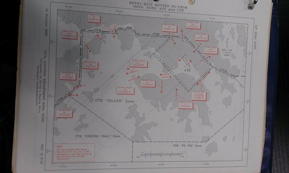
10.2.1 Aircraft departing from or returning to the KTATZ normally are to do so via East Pass.
10.2.2 Traffic circuit is on the east side of the runway. Circuits are left hand on Runway 13 and right hand on Runway 31. Circuit altitude is 1000ft.
10.2.3 Subject to approval from Aerodrome Control, acircuit may be carried out on the west side of the runway for recovery only, when unforeseen circumstances preclude safe use of the circuit on the east side of the runway.
10.2.4 The Runway 13 base leg is over Taxiway D2. Pilot making approaches from the circuit to runway 13 are not to descend below 400ft until established on final.
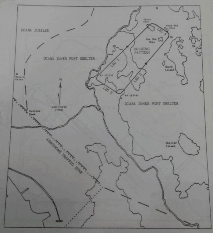
10.3 Inner Port Shelter Holding Pattern (IPSHP)
10.3.1 A holding pattern is established in UCARA Port Shelter near East Pass. The minimum holding altitude is 1500ft. The orientation of each leg and direction of turn are as follows,
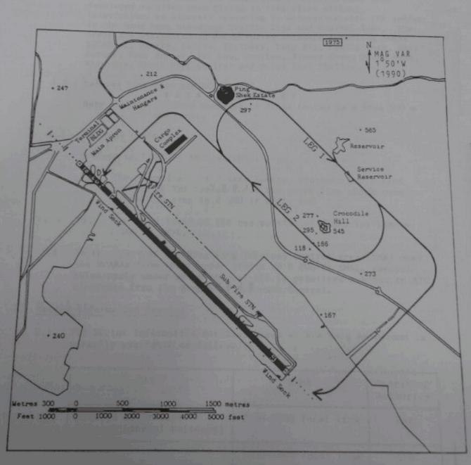
10.4 Aerodrame Traffic Zone Holding Pattern (KTATZHP)
10.4.1 The Holding Pattern is a right hand race-track whether to land on Runway 13 or 31. The orientation of each leg and direction of turn are as follows.
VFR Helicopter
1 Flying in KTATZ
1.1 Alternative Landing Site
All pilots operating from Kai Tak must select an alternative landing site (i.e. LT16 / VHSK) prior to takeoff as part of their preflight procedures.
1.2 Departures and Arrivals
1.2.1 On departures with a headwind or crosswind component not exceeding the limitations set forth below, pilots should consider making use of the full length of the old LATRA for a “normal transition takeoff” and establish 60 KIAS for climbing right after the fences along the southeastern perimeter of the HKAC. Pilots should exercise with extreme care to avoid flying near other aircraft and follow the “Arrival and Departure Path” west of the Runway.
1.2.2 On arrivals with a downwind component not exceeding the limitations set forth below, pilots should start descent from 500ft AGL at 60 KIAS at the North end of the Runway and expect to join the “Arrival and Departure Path” at 200ft AGL at approximate 40 KIAS. Pilots should avoid a combination of airspeeds and vertical descent rates favoring “settling with power” (also known as “vortex ring state”) throughout the descent approach. In either case that any pilot is unlikely to establish a steady approach within the wind limitations set forth below or the latest wind check reveals the conditions exceeding the limitations on return, he/she must consider proceeding to the alternative site to land into wind.
1.2.3 Under any circumstance, pilots are required to review all suitable areas along the “Arrival and Departure Path” prior to takeoff for the purpose of forced landing without danger to persons or property on the surface, in the event of failure of a power unit. Wind Limitations on Departures and Arrivals Departures with a downwind component of more than 5 knots or crosswind component of more than 10 knots are not permitted.
1.2.4 Arrivals with a downwind or crosswind component of more than 10 knots is not permitted. Wind speeds are to be taken from the “10-minute Mean Wind” at Kai Tak as recorded by the Hong Kong Observatory.
1.3 Max Gross Weight
Pilots should allow at least 10% margin between the maximum allowable takeoff weight and the maximum gross weight laid on the Pilot’s Operating Handbook when operating at Kai Tak.