VH
Hong Kong (VHHH/VHHX) Terminal Procedures
| SID 07 | SID 07 Noise | SID 25 | TTR | EXIT | SID 13 | SID 31 |
|---|---|---|---|---|---|---|
| BEKOL3A/1E | ATENA2A/2E ATENA1X/Z | BEKOL2B/1F | - | BEKOL | BEKOL1A | BEKOL2C |
| LAKES3A/1E | VENGO1A/2E VENGO1X/Z | LAKES2B/1F | V1 | DOTMI | DOTMI1A | DOTMI2C |
| V13 | LELIM | - | - | |||
| OCEAN2A/1E | RASSE3A/2E RASSE1X/Z | OCEAN2B/1F | V2 | ELATO | ELATO1A | ELATO2C |
| V3 | ENVAR | ENVAR1A | ENVAR2C | |||
| OCEAN2A/1E | SKATE3A/2E SKATE1X/Z | OCEAN2B/1F | V4 | NOMAN | NOMAN1B(1A*) | NOMAN2D(2C*) |
| V5 | SABNO | SABNO1B(1A*) | SABNO2D(2C*) | |||
| PECAN1A/1E | PECAN1A/1E PECAN1X/Z | PECAN1B/1F | V12 | EPDOS | EPDOS1A | EPDOS2C |
| V11 | IDOSI | IDOSI1B(1A*) | IDOSI2D(2C*) | |||
| V10 | SIKOU | SIKOU1A | SIKOU2C/2E | |||
| For VMMC Macao | PECAN | DCT | CHALI | - | - | |
| For ZGSD Zhuhai | PECAN | DCT | FOXTROT | - | - | |
| ENTRY | TTR | STAR 07 | STAR 25 | RNP1 25 |
|---|---|---|---|---|
| SIERA | - | SIERA7A/C | SIERA6B/D | SIERA1G |
| LELIM | V591 | ABBEY3A | ABBEY2B | ABBEY1G |
| DOTMI | V512 | |||
| ELATO | V522 | |||
| V525 | BETTY2A | BETTY2B | BETTY1G | |
| NOMAN | V532 | |||
| SABNO | V542 | |||
| DULOP | V551 | |||
| DCT MEPUT | (W29) | |||
| IDOSI | V561 | CANTO3A | CANTO2B | CANTO1G |
| SIKOU | V571 | |||
| VMMC ALLEY | DCT | |||
| ZGSD FOXTROT | DCT |
* Not recommended due to the complication of the departure route.
- VHHX Arrival:
- B330 TAMOT Inbound: DCT MIKE DCT CHALIE DCT CH
- RWY 13: DCT CH
- RWY 31: Radar Vector to LIMA and ILS 31
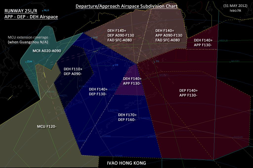
- VHHH_APP/DEP Sector SFC-FL250
- when VMMC_APP is NOT available, extend to VMMC_APP sector (SFC-FL120).
VMMC
Macau (VMMC) Terminal Procedures
| SID 34 (HK07) | SID 34 (HK25) | SID 16 | TTR | EXIT |
|---|---|---|---|---|
| SOUSA3T (2V+) | SOUSA3U (2W+) | SOUSA2P | V1 | DOTMI |
| V13 | LELIM | |||
| CONGA2T (1V+) | CONGA3U (2W+) | CONGA2P | V2 | ELATO |
| V3 | ENVAR | |||
| GRUPA2T (1V+) | GRUPA3U (2W+) | GRUPA2P | V4 | NOMAN |
| V5 | SABNO | |||
| ALLEY2T (1V+) | ALLEY2U (1W+) | ALLEY2P | V10 | SIKOU |
| V31 | IDOSI | |||
| V32 | EPDOS | |||
| DCT | CANTO VHHH | |||
| BIGRO5D/7D(8D#) | BIGRO2D/3D(1D*) | - | BIGRO | |
| MIPAG5D/7D(6D#) | MIPAG2D/9D(1D*) | - | MIPAG | |
| NLG5D/7D(6D#) | NLG2D/9D(1D*) | - | NLG | |
| SHL5D/7D(6D#) | SHL2D/9D(1D*) | - | SHL | |
| ENTRY | TRANSITIION | STAR 34 | STAR 16 |
|---|---|---|---|
| DOTMI | DCT SAMMI J101 SMT | SMT4A | SMT5B |
| ELATO | J101 SMT | SMT4A | SMT5B |
| SABNO | DCT TOFEE DCT SUKER DCT ALDOM J103 ROBIN DCT CHALI | CHALI4A | CHALI5B |
| SIKOU | J104 CHALI | ||
| IDOSI | DCT DASON J104 CHALI | CHALI4A | CHALI5B |
| DUMOL | J103 ROBIN DCT CHALI | ||
| PECAN | DCT | ||
| BIGRO | - | BIGRO6A/7A | BIGRO9A/1A |
| CON | - | CON6A(7A*) | CON9A |
| POU | - | POU6A/8A(7A*) | POU9A/1A |
| NLG | - | NLG5A/7A(6A*) | - |
For use when (*MCU / #ZAO / +LKC) DVOR is not available.
VMMC STAR-Approach Combination
| STAR Entry Point | LOC Z 16 LOC Y 16 (When MCU Unusable) | RNAV LOC X 16 RNP Y (LNAV) 16 RNP Z (AR) 16 | ILS Z 34 VOR 34 | ILS Y 34 | RNAV ILS X 34 RNAV (GNSS) 34 |
|---|---|---|---|---|---|
| (STAR End Point) | ZUH @1800m (5910ft) NLG @2100m (6890ft) | ZUH @5900ft NLG @6900ft | UJ @2400m (7880ft) MCU @2100m (6890ft) HAZEL @FL110 MC611 @6000ft | UJ @2400m (7880ft) ZAO D6.7 @2100m (6890ft) HAZEL @FL110 MC611 @6000ft | UJ @7900ft MCU @6900ft HAZEL @FL110 MC611 @6000ft |
| BIGRO | BIGRO9A | BIGRO1A | BIGRO6A | - | BIGRO7A |
| NLG Nanlang | (DCT to IAF) | (DCT to IAF) | NLG5A | NLG6A | NLG7A |
| POU Pingzhou | POU9A | POU1A | POU6A | POU7A | POU8A |
| CON Conghua | CON9A | - | CON6A | CON7A | - |
| SMT Siu Mo To | - | SMT5B | SMT4A | SMT4A | SMT4A |
| CHALI | - | CHALI5B | CHALI4A | CHALI4A | CHALI4A |
- Flights from Manila FIR to Macao Airport should route via A583 and to cross SABNO at FL340 or below:
- ATC shall provide guidance for NOMAN inbound traffic. Route: NOMAN DCT ARROW J103 ROBIN DCT CHALI
- VMMC_APP SFC-FL120 123.950 (Radio Callsign: Hong Kong Radar)
- When Zhuhai/Guangzhou ATC is NOT available:
- Radar coverage extension: VMMC_APP / VHHH_APP / HKG_CTR covers for LLZ/DME 16 procedure flight path.
- When any of the Zhuhai/Guangzhou ATC is available:
- (APP/CTR) Hand on/off to Guangzhou should be at HKFIR Boundary: ROMEO-MCU-LATOP;
- (VMMC_TWR) RWY 34 deps SID ALLEY, CONGA, GRUPA, SOUSA hand off to HK APP/DEP;
- (VMMC_TWR) RWY 34 deps SID BIGRO, NLG, SHL hand off to Guangzhou;
- (VMMC_TWR) RWY 16 deps all hand off to HK APP/DEP; accepts LLZ/DME 16 TFC at LATOP.
Briefing
- KEEP CALM
- Be prepared to handle large amount of traffic.
- Speak Clearly and carefully to deliver messages.
- DO NOT enter a Holding, unless more than 15 arrival flights in 30 minutes.
- Ground
- Give standard taxi instruction, include taxiways.
- To cross runway, aircraft MUST contact TOWER at holding point and back to GROUND after crossing.
- DO NOT assign Mid-field gates, unless the pilot requests.
- Clearance Delivery
- Squawk codes, use ATC Dashboard SSR Assign Portal.
- Give radar vector clearance, in case the pilot cannot carry out approriate SID/flight route.
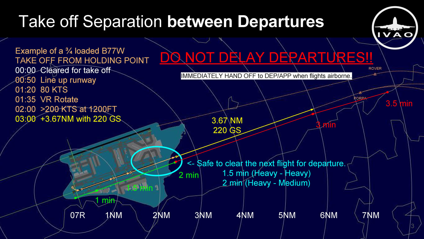
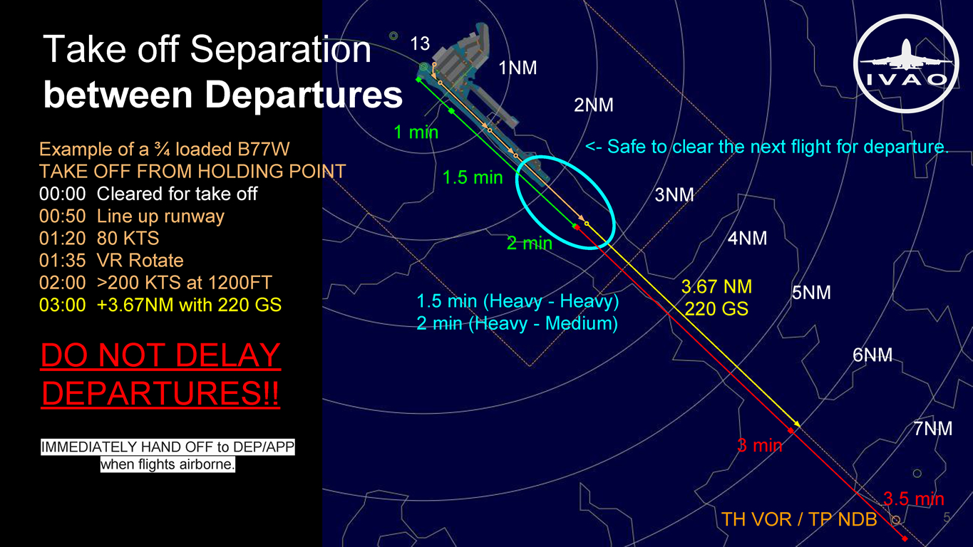
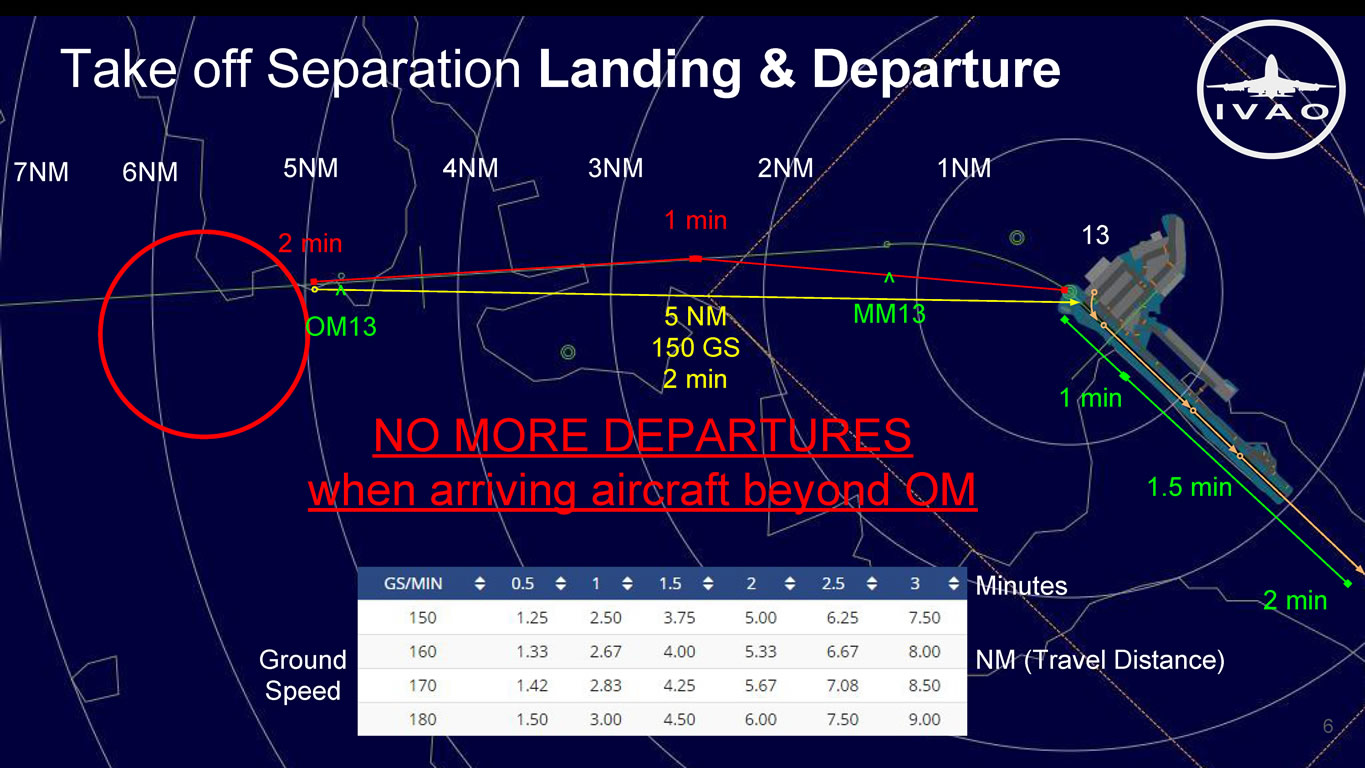
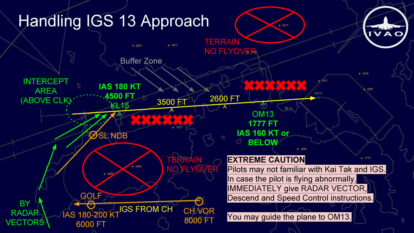
- Kai Tak IGS 13
- EXTREME CAUTION:
- Pilots may not familiar with the procedures. In case the pilot is flying abnormally, IMMEDIATELY give (1) Radar Vector, (2) Descend and (3) Speed Control instructions. Guide the plane to OM13.
- Departure 07L/R:
- No take off when flights passing GOLF for KL15.
- Landing 25L/R:
- Missed APCH maintain 3000 FT or Turn right Heading 270.
Tower
Runway Operations
| RWY | IAP | MAG BRG | ELEV | Initial climb | TORA | TORA |
|---|---|---|---|---|---|---|
| VHHH 07L | ILS 111.10 | 074º | 22 FT | 5000 FT | 3800 m | A3: 3306 m |
| VHHH 07R | ILS 109.30 | 074º | 27 FT | 5000 FT | 3800 m | J3: 3130 m K2: 2720 m |
| VHHH 25L | ILS 108.90 | 254º | 22 FT | 5000 FT | 3800 m | J9: 3200 m K6: 2880 m |
| VHHH 25R | ILS 110.90 | 254º | 27 FT | 5000 FT | 3800 m | A10: 3247 m |
| VHHX 13 | IGS 111.90 | 136º | 15 FT | 7000 FT | 3331 m | |
| VHHX 31 | ILS 109.90 | 316º | 15 FT | 4000 FT | 2892 m | |
| VMMC 16 | LOC 111.70 | 163º | 20 FT | 4000 FT | 3225 m | G: 3080 m |
| VMMC 34 | ILS 109.70 | 343º | 20 FT | 6000 FT | 3300 m | D: 3100 m E: 2530 m F: 2015 m |
Spacing
Wake Turbulence Separation Minima
| Leading Aircraft | Following Aircraft | Radar Separation | Tower Separation | Tower Separation (Intersection) |
|---|---|---|---|---|
| Similar Type | 4 NM | 90 Seconds | 90 Seconds | |
| SUPER | HEAVY | 6 NM | 2 Minutes | 2 Minutes |
| MEDIUM | 7 NM | 3 Minutes | 4 Minutes | |
| LIGHT | 8 NM | 3 Minutes | 4 Minutes | |
| HEAVY | MEDIUM | 5 NM | 2 Minutes | 3 Minutes |
| LIGHT | 6 NM | 2 Minutes | 3 Minutes | |
| MEDIUM | LIGHT | 5 NM | 2 Minutes | 3 Minutes |
Speed Control
| RWY | Final Approach | Departure | ||
|---|---|---|---|---|
| VHHH 07L/R | 210 KTS LIMES | 180 KTS TONIC/STELA | 150-160 KTS 4 DME | 180-220 KTS PORPA/ROVER |
| VHHH 25L/R | 180 KTS 15 to 7 DME | 150-160 KTS 4 DME | 180-230 KTS PRAWN |
|
| VHHX 13/31 | 250 KTS 30 CH/TH DME | 180 KTS 15 DME | 160 KTS Outer Marker | - |
| VMMC 16/34 | 190 KTS at Turning | 205 KTS at Turning | ||
Inter-arrival Spacing and Metering at Feeder Gates
| Mode | RWY Spacing | Time Interval | In-trail spacing (NM) [Based on 280KIAS at Gate] |
||
|---|---|---|---|---|---|
| NM | Secs | Single Feed | Duel Feed | Three Feed |
|
| Simultaneous | 4 | 100 | 10 | 20 | 30 |
| Co-ordinated | 5 | 125 | 12 | 24 | 36 |
| Co-ordinated | 6 | 150 | 15 | 30 | 45 |
| VOR/DME RWY 25 | 7 | 175 | 18 | 36 | 54 |
| SGL RWY | 8 | 200 | 20 | 40 | 60 |
LVP [Based on 250KIAS at Gate] |
|||||
| Arrivals only | 7 | 175 | 15 | 30 | 45 |
| Departure spacing required | 12 | 300 | 25 | 50 | 76 |
| Mixed RWY | 5 | 125 | 10 | 20 | 30 |
FLAS (H)
Flight Level Assignment Scheme (H-view)
Effective Date: January 7, 2016
| FROM – TO | LEVELS | FROM – TO | LEVELS | ||
|---|---|---|---|---|---|
| HK – Taipei | F270,290,310,330, 350,370,390,410 (F290 not available 2300-1159 UTC) | Taipei – HK | F300,320,340, 360,380,400 |
||
| HK – Taipei | F290,330,370,410 | Taipei – HK | F300,320,340, 360,380,400 |
||
| HK – Taipei | F290,330,370, 410 (F390) | Taipei – HK | F300,340,380,400 | ||
| HK – Manila | F290,330,370,410 | Manila – HK | F300,340,380 | ||
| Manila – HK | F300,380 | ||||
| HK – Sanya | F280,310,320, 350,360,390,400 | Sanya – HK | F270,310,320, 350,360,390,400 |
||
| HK – Sanya | F280,300,340, 380,400,430 | Sanya – HK | F270,290,330, 370,390,410,450 |
||
| HK – Zhanjiang | To Haikou: S0660, S0720 To Sanya: S0840 ASSAD: S1040, S1160, S1220 | Zhanjiang – HK | From Haikou: S0630 From Sanya: S0810, S0890 ASSAD: S1010, S1070, S1130, S1190, S1250 |
||
| HK – Zhanjiang | To Zhanjiang: S0600 To Beihai/Nanning: S0720, S0780 Other: S0980, S1040, S1100, S1160, S1220 | Zhanjiang – HK | From Zhanjiang: S0570 | ||
| HK – Guangzhou | Land ZGGG: S0450 (S0420) | Guangzhou – HK | Transit: S0840, S0920, S0980, S1040, S1100, S1160, S1220* | ||
| HK – Guangzhou | Land ZGGG: S0420 (S0450) Depart VHHH: S0690 Transit flights: S0890*, S0950, S1010, S1070, S1130, S1190 | Guangzhou – HK | Landing VHHH: F190, F210, F230 Depart ZGGG: F230, F250 |
||
| HK – Guangzhou | To Shantou: S0420 To Xiamen/Jinjiang: S0690, S0750 To Fuzhou/Wuyishan: S0690, S0750, S0810, F290 Others: F290, F330, F350, F390 | Guangzhou – HK | From Shantou: S0450 All: S0660, S0720, S0780, F280, F300 (Transit HKFIR only: F360, F380) |
||
| HK – Guangzhou | To Shanghai Pudong: F330 To Qingdao/Yantai/Dalian: F330, F350 | Guangzhou – HK | From Shanghai Pudong/Qingdao/Yantai/Dalian: F300 | ||
FLAS (V)
Flight Level Assignment Scheme (V-view)
Last Updated: August 6, 2014
| FEET | A1/P901 IKELA | L642 EPKAL | M771 DOSUT | M772 ASOBA | A461/M501/A583 NOMAN SABNO | G86 KAPLI | G581 ENVAR | M750 ENVAR | A1/G581 ELATO |
||||
|---|---|---|---|---|---|---|---|---|---|---|---|---|---|
| OUT | IN | OUT | IN | IN | OUT | IN | OUT | IN | OUT | OUT | IN | OUT | |
| SW | NE | SW | NE | N | SE | NW | E | W | E | E | W | E | |
| F410 | F410 | F410 | F410 | F410 | F410 | ||||||||
| F400 | F400 | F400 | F400 | F400 | F400 | ||||||||
| F390 | F390 | F390 | F390 | F390 | F390 | ||||||||
| F380 | F380 | F380 | F380 | F380 | F380 | ||||||||
| F370 | F370 | F370 | F370 | F370 | F370 | ||||||||
| F360 | F360 | F360 | F360 | ||||||||||
| F350 | F350 | F350 | F350 | ||||||||||
| F340 | F340 | F340 | F340 | F340 | |||||||||
| F330 | F330 | F330 | F330 | F330 | F330 | ||||||||
| F320 | F320 | F320 | F320 | ||||||||||
| F310 | F310 | F310 | F310 | ||||||||||
| F300 | F300 | F300 | F300 | F300 | F300 | ||||||||
| F290 | F290 | F290 | F290 | F290 | F290 | ||||||||
| F280 | F280 | F280 | F280 | F280 | F280 | ||||||||
| F270 | F270 | F270 | F270 | F270 | F270 | F270 | F270 | ||||||
Flight Level Assignment Scheme (V-view) China
Effective Date: January 7, 2016
| FEET | M | A202 SIKOU | R339 SIKOU | R473 SIERA | B330 TAMOT | W68 TAMOT | A461 BEKOL | A470 DOTMI | M503 LELIM |
||||
|---|---|---|---|---|---|---|---|---|---|---|---|---|---|
| OUT | IN | OUT | IN | IN | IN | OUT | OUT | OUT | IN | IN | OUT | ||
| SW | NE | NW | SE | S | S | N | N | NE | SW | SW | NE | ||
| F411 | S1250 | S1250 | |||||||||||
| F401 | S1220 | S1220 | S1220 | S1220 | |||||||||
| F391 | S1190 | S1190 | S1190 | F390 | |||||||||
| F381 | S1160 | S1160 | S1160 | S1160 | F380 | ||||||||
| F371 | S1130 | S1130 | S1130 | ||||||||||
| F361 | S1100 | S1100 | S1100 | F360 | |||||||||
| F351 | S1070 | S1070 | S1070 | F350 | F350 | ||||||||
| F341 | S1040 | S1040 | S1040 | S1040 | Shanghai | ||||||||
| F331 | S1010 | S1010 | S1010 | F330 | F330 | ||||||||
| F321 | S0980 | S0980 | S0980 | ||||||||||
| F311 | S0950 | S0950 | Land HK | ||||||||||
| F301 | S0920 | Sanya | S0920 | Fuzhou | F300 | F300 | |||||||
| F291 | S0890 | S0890 | S0890 | F290 | |||||||||
| F276 | S0840 | S0840 | S0840 | F280 | |||||||||
| F266 | S0810 | S0810 | Transit | S0810 | |||||||||
| F256 | S0780 | S0780 | F250 | Xiaman | S0780 | ||||||||
| F246 | S0750 | Haikou | S0750 | ||||||||||
| F236 | S0720 | S0720 | S0720 | F230 | Dep HK | S0720 | |||||||
| F226 | S0690 | Land HK | S0690 | S0690 | |||||||||
| F216 | S0660 | S0660 | F210 | S0660 | |||||||||
| F207 | S0630 | S630 | Zhanjiang | ||||||||||
| F197 | S0600 | S0600 | F190 | ||||||||||
| F187 | S0570 | S0570 | Guangzhou | Shantou | |||||||||
| F148 | S0450 | S0450 | S0450 | S0450 | |||||||||
| F138 | S0420 | S0420 | S0420 | S0420 | |||||||||
Airspace
Airspace Chart
Transit
| Entry Route | RTE in HKFIR | Connecting Route | Note |
|---|---|---|---|
| A470 | DOTMI DCT SOUSA DCT CONGA V2 ELATO | A1/G581 | |
| DOTMI DCT SOUSA DCT CONGA V3 ENVAR | M750 | ||
| DOTMI DCT ENROM DCT NOMAN | A461/M501 | ||
| DOTMI DCT ENROM DCT SABNO | A583 | ||
| DOTMI DCT ENROM DCT SULUX DCT EPKAL | L642 | ||
| DOTMI DCT ENROM DCT SULUX DCT IGLEG DCT IKELA | A1 | ||
| DOTMI DCT ENROM DCT ALLEY V10 SIKOU | A202/R339 | ||
| A1/G581 | ELATO DCT MAGOG DCT DOTMI | A470 | |
| ELATO J101 PONTI DCT BEKOL | A461 | ||
| G86 | KAPLI DCT MADRU DCT SULUX DCT IGLEG DCT IKELA | A1 | |
| KAPLI DCT ALLEY V10 SIKOU | A202/R339 | ||
| A461 | NOMAN DCT SANKU DCT SOUSA V1 DOTMI | A470 | |
| Not Available | A202/R339 | ||
| A583 | SABNO DCT LEGOD DCT BEKOL | A461 | |
| SABNO DCT SIKOU | A202/R339 | ||
| M772 | ASOBA M772 DULOP Q1 CARSO DCT NOBAD DCT SANKU DCT SOUSA V1 DOTMI | A470 | |
| ASOBA M772 DULOP M771 DUMOL J103 BEKOL | A461 | ||
| M771 | DOSUT M771 DULOP Q1 CARSO DCT NOBAD DCT SANKU DCT SOUSA V1 DOTMI | A470 | |
| DOSUT M771 DUMOL DCT DAGBU DCT SIKOU | A202/R339 | ||
| DOSUT M771 DUMOL J103 BEKOL | A461 | ||
| A1 | IKELA DCT MORTU DCT NOBAD DCT SANKU DCT SOUSA V1 DOTMI | A470 | |
| IKELA DCT MORTU DCT NOBAD DCT ELATO | A1 | ||
| IKELA DCT MORTU DCT NOBAD DCT ENVAR | M750 | ||
| IKELA DCT MORTU DCT NOBAD DCT KAPLI | G86 | 5 | |
| IKELA P901 IDOSI DCT DAGBU DCT SIKOU | A202/R339 | 4 | |
| IKELA A1 IDOSI DCT DAGBU DCT SIKOU | 4 | ||
| IKELA P901 IDOSI DCT CH A461 BEKOL | A461 | 4 | |
| IKELA A1 IDOSI DCT CH A461 BEKOL | 4 | ||
| B330/W18 | TAMOT B330 CH DCT RASSE DCT CONGA V2 ELATO | A1 | |
| TAMOT B330 CH DCT RASSE DCT CONGA V2 ELATO | G581 | ||
| TAMOT B330 CH DCT RASSE DCT CONGA V3 ENVAR | M750 | ||
| TAMOT B330 CH DCT RASSE DCT CONGA V3 ENVAR M750 DADON | G581 | ||
| TAMOT B330 CH DCT GRUPA V4 NOMAN | A461/M501 | ||
| TAMOT B330 CH DCT GRUPA V5 SABNO | A583 | ||
| TAMOT DCT ALLEY V32 EPDOS L642 | L642 | ||
| TAMOT DCT ALLEY V31 IDOSI P901 IKELA | A1 | 4 | |
| TAMOT DCT ALLEY V31 IDOSI A1 IKELA | 4 | ||
| TAMOT DCT ALLEY V10 SIKOU | A202/R339 | ||
| A202/R339 | SIKOU DCT DAGBU DCT IDOSI P901 IKELA | A1 | 4 |
| SIKOU DCT DAGBU DCT IDOSI A1 IKELA | 4 | ||
| SIKOU DCT DAGBU DCT EPDOS L642 | L642 | ||
| SIKOU J104 CHALI DCT LENBU DCT GRUPA V4 NOMAN | A461/M501 | ||
| SIKOU J104 CHALI DCT LENBU DCT GRUPA V5 SABNO | A583 | ||
| SIKOU J104 CHALI DCT BEKOL | A461 | ||
| SIKOU J104 CHALI DCT KAPLI | G86 |
1. Normally for non-RNAV 5 compliant or non-RVSM approved aircraft.
2. To operate between FL290 and FL410 aircraft must be RNAV 5 compliant and RVSM approved.
3. Route available only during the period 1700 – 0059 UTC, flight plan via G86 KAPLI during the period 0100 – 1659 UTC.
4. Route via P901 at FL290 or above, or A1 at FL280 or below. To operate at FL290 or above aircraft must be RNP 10 compliant.
5. Between 1700 – 2200 UTC, Taipei ACC only accept eastbound traffic entering the Taipei FIR via KAPLI to flights transiting Taipei FIR to Fukuoka FIR and routing via G581 IGURU only or destined for aerodromes in Taipei FIR.
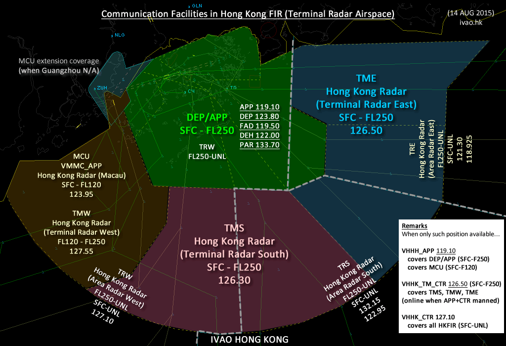
Frequencies
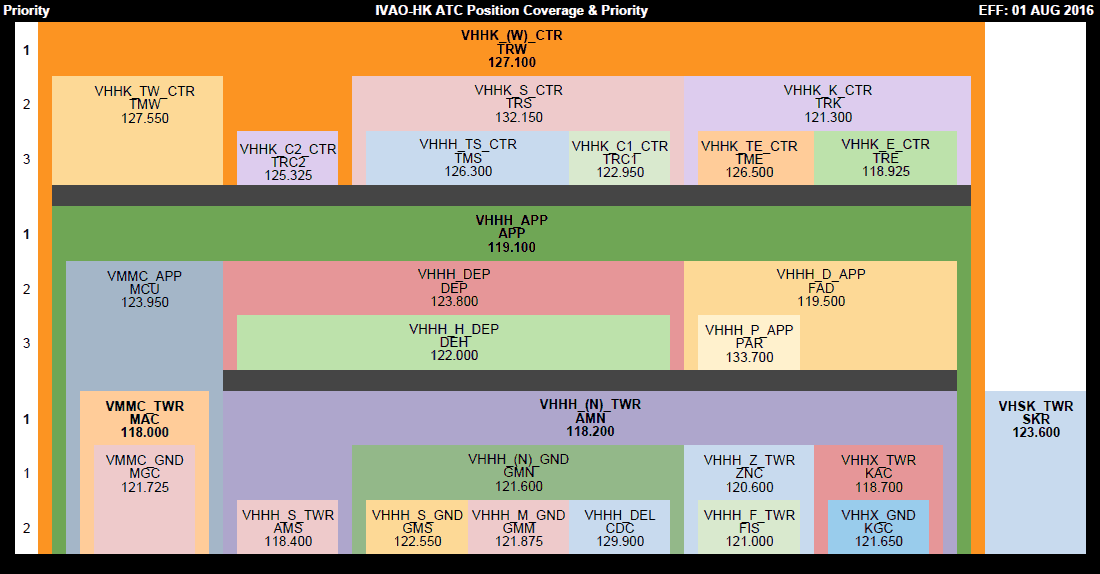
Communication Facilities in IVAO
Effective Date: September 10, 2020
| Frequency | Sector | Callsign | Radio Callsign |
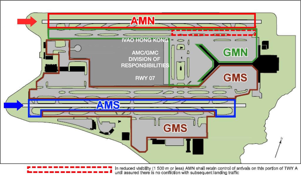
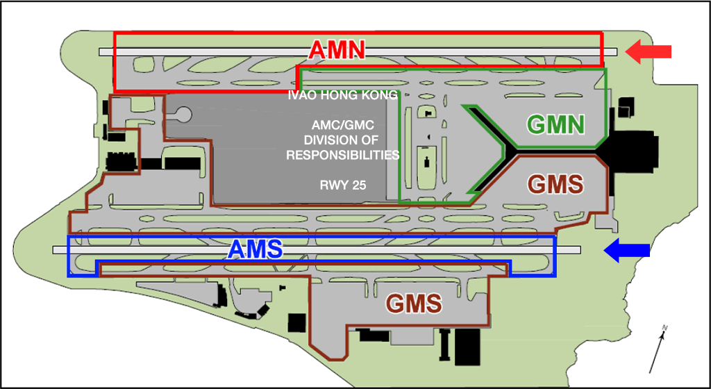
|---|---|---|---|
| 122.150 | CDC | VHHH_DEL | Hong Kong Delivery |
| 121.600 | GMN | VHHH_(N)_GND | Hong Kong Ground (North) |
| 122.550 | GMS | VHHH_S_GND | Hong Kong Ground (South) |
| 121.875 | GMM | VHHH_M_GND | Hong Kong Ground Mid-field |
| 118.200 | AMN | VHHH_(N)_TWR | Hong Kong Tower (North) |
| 118.400 | AMS | VHHH_S_TWR | Hong Kong Tower (South) |
| 118.700 | KAC | VHHX_TWR | Kai Tak Tower |
| 118.000 | MAC | VMMC_TWR | Macau Tower |
| 120.600 | ZNC | VHHH_Z_TWR | Hong Kong Zone |
| 121.000 | FIS | VHHH_F_TWR | Hong Kong Information |
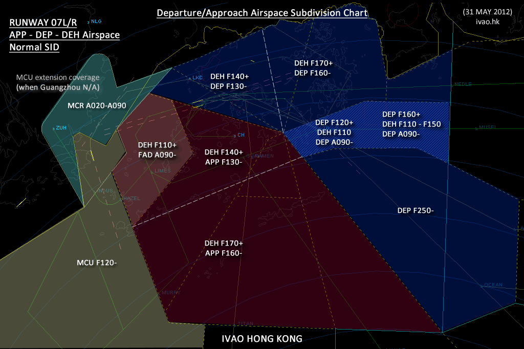
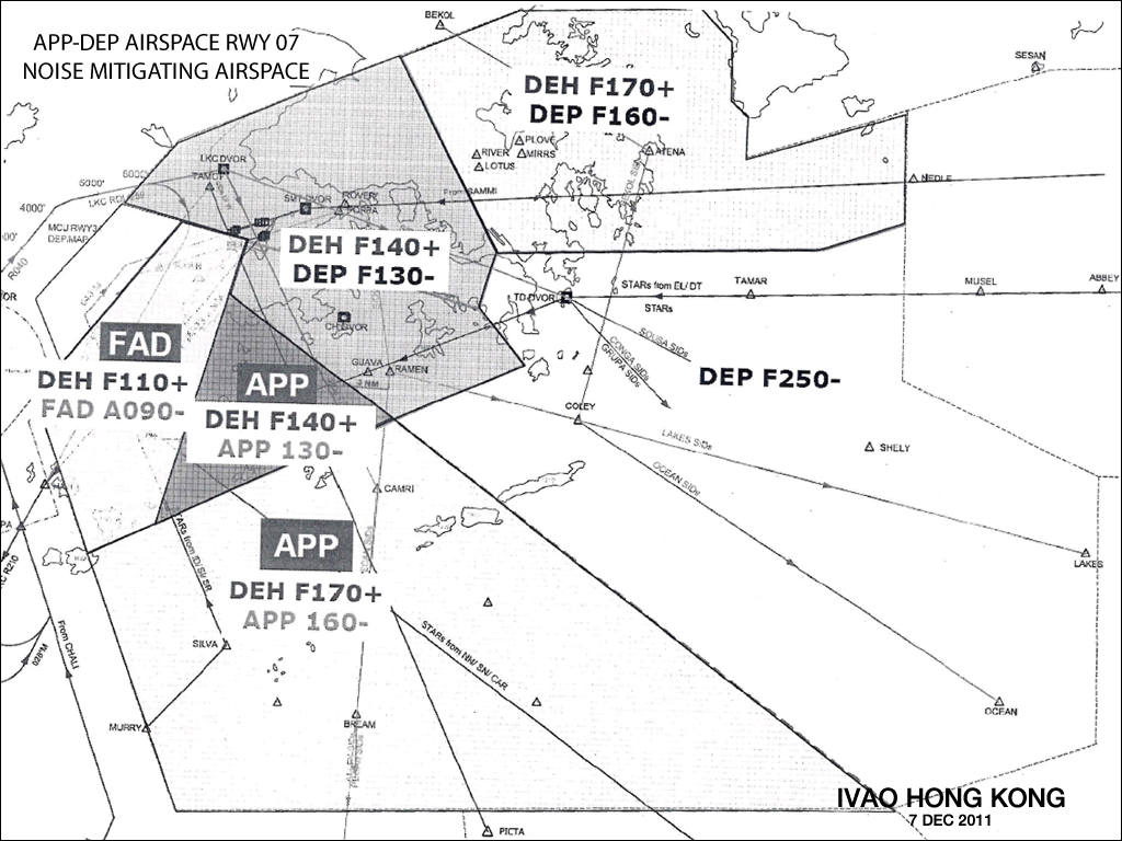
| 119.100 | APP | VHHH_APP | Hong Kong Approach |
| 123.800 | DEP | VHHH_DEP | Hong Kong Departure |
| 122.000 | DEH | VHHH_H_DEP | Hong Kong Departure (High) |
| 119.500 | FAD | VHHH_D_APP | Hong Kong Director |
| 133.700 | PAR | VHHH_P_APP | Hong Kong Precision |
| 123.950 | MCU | VMMC_APP | Hong Kong Radar (Macao) |
| 127.100 | TRW | VHHK_(W)CTR | Hong Kong Radar (West) |
| 121.300 | TRK | VHHK_K_CTR | |
| 132.150 | TRS | VHHK_S_CTR | |
| 118.925 | TRE | VHHK_E_CTR | |
| 132.525 | TRU | VHHK_U_CTR | |
| 122.950 | TRC1 | VHHK_C1_CTR | |
| 125.325 | TRC2 | VHHK_C2_CTR | |
| 126.300 | TMS | VHHK_TC_CTR | (All Terminal) |
| 126.500 | TME | VHHK_TE_CTR | (Terminal East) |
| 126.300 | TMS | VHHK_TS_CTR | (Terminal South) |
| 127.550 | TMW | VHHK_TW_CTR | (Terminal West) |
Phraseology
Standard Phraseology
Last Updated: February 28, 2015
| Position | Circumstances | Phraseology |
|---|---|---|
| DEL | SID clearance | (A/c callsign) cleared to (destination), (SID name) departure, squawk (transponder code). |
| DEL | Radar Vector departure clearance | (A/c callsign) cleared to (destination), radar vector for departure, RWY ( - - ), initial climb to ( - - ), squawk (transponder code). |
| GND | Push back and engine start | Start up and standard pushback approved, face ( east/west/south/north ). |
| GND | Push back and engine start | Standby for push back and start up. |
| GND | Push back and engine start | Expect departure at time ( - - ), standby for start up. |
| GND | Taxi instruction | Taxi holding point TWY ( - - ), via ( - - - ), RWY ( - - ), QNH ( - - - ). |
| GND | Taxi instruction | Taxi ( - - ) hold at ( - - ), Give way to ( - - - ) then follow that aircraft to ( - - - ), QNH ( - - - ). |
| GND | Taxi instruction | Hold position. |
| TWR | Prior to take-off | Report when ready for departure. |
| TWR | Prior to take-off | Are you ready for immediate departure? |
| TWR | Prior to take-off | Line up and wait. |
| TWR | Take-off | RWY ( - - ) cleared for take-off |
| TWR | Take-off | RWY ( - - ) cleared for immediate take-off. |
| TWR | Take-off | Take-off immediately or vacate the runway. |
| TWR | Cancel take-off | Hold position, cancel take-off I say again cancel take-off. |
| TWR | Stop a take-off in emergency conditions | (Callsign) Stop immediately (Callsign) stop immediately. |
| TWR | Landing | Continue approach. |
| TWR | Landing | Continue approach prepare for possible go around. |
| TWR | Landing | RWY ( - - ) cleared to land wind (- - - / - - kt). |
| TWR | Landing | RWY ( - - ) cleared touch and go. |
| TWR | Landing during RRSM | (Callsign) preceding B747 landing about to vacate the runway, surface wind (- - - / - - kt) runway ( - - ) cleared to land. |
| TWR | Landing during RRSM | (Callsign) departing MD11 ahead about to rotate, surface wind (- - - / - - kt) runway ( - - ) cleared to land. |
| TWR | After landing | Contact Ground frequency ( - - - ). |
| TWR | After landing | Take (first) TWY ( - - ) (left or right) and contact Ground frequency ( - - - ). |
| TWR | Missed approach | Go around, I say again go around (make a standard missed approach). |
| TWR | Cross the Runway (Ground) | Standby, hold at holding point ( - - - ). |
| TWR | Cross the Runway (Ground) | Cleared to cross runway, report vacated. |
| TWR | Cross runway corridor (Air) | Cleared runway (07/25) corridor. |
| APP | Approach instructions | Cleared (type of approach) approach RWY ( - - ). |
| APP/CTR | Level changes | Climb / descend to ( - - - ) |
| APP/CTR | Re-routing | Proceed direct ( - - - ). |
| APP/CTR | Radar vectoring | Continue heading ( - - - ). |
| APP/CTR | Radar vectoring | Continue present heading. |
| APP/CTR | Radar vectoring | Fly heading ( - - - ). |
| APP/CTR | Radar vectoring | Turn left / right heading ( - - - ). |
| APP/CTR | Radar vectoring | Turn left/right heading ( - - - ), radar vector for (type of approach) approach RWY ( - - ). |
| APP/CTR | Radar vectoring | Leave (location) heading ( - - - ) for (reason, e.g. sequencing, base leg, final). |
| APP/CTR | After vectoring/holding | Resume own navigation (specific instructions) |
| APP/CTR | Apply speed control | Report speed. |
| APP/CTR | Apply speed control | Reduce/increase speed to ( - - - ) KT. |
| APP/CTR | Apply speed control | Increase speed to ( - - - ) KT (or greater). |
| APP/CTR | Apply speed control | Maintain present speed. |
| APP/CTR | Apply speed control | Maintain ( - - - ) KT (or greater). |
| APP/CTR | Apply speed control | Reduce to minimum clean speed. |
| APP/CTR | Apply speed control | Reduce to minimum approach speed. |
| APP/CTR | Apply speed control | No (ATC) speed restriction. |
| APP/CTR | Holding | Join ( - - - ) holding pattern. Expect ( - - ) minutes delay. |
| APP/CTR | Avoiding action (Heading) | Turn (left / right) immediately heading ( - - -), to avoid (unidentified) traffic at (bearing by clock reference and distance). |
| APP/CTR | Avoiding action (Degrees) | Turn (left / right) ( - - - ) degrees immediately to avoid (unidentified) traffic at (bearing by clock reference and distance). |
| APP/CTR | When clear of traffic | Clear of traffic (specific instructions) |
| APP/CTR | Approving weather deviation on ATS routes | Deviation up to 25 NM left / right of track approved. (Deviation beyond 25 NM will be outside controlled airspace and subject to pilot's discretion.) |
Squawk/Gate
WXR
EMEG
Emergency Procedures
| Checklist - ASSIST | |
|---|---|
| A | Acknowledge the emergency call |
| S | Separate the emergency aircraft from other traffic, prioritize it for landing if necessary |
| S | Silence the frequency and non-urgent calls (as required) |
| I | Inform adjecent units and controllers |
| S | Support the pilot by providing room for manoeuvre and relavant information |
| T | Time: provide time for the crew to assess the situation |
Selection of Runway for Emergency Landing - Guidelines: |
|
| (a) | in a dire situation when a aircraft requires to land as soon as possible, the distance to touchdown on the south runway is slightly shorter from most directions; |
| (b) | in less critical situations the north runway has a more open environment and the approaches are less susceptible to windshear and turbulence; |
| (c) | in a situation where the emergency may result in the runway being temporarily closed, the north runway is preferable; |
| (d) | AFC are able to provide an adequate response to an incident on either runway, but more facilities and manpower are readily available to the south runway; |
| (e) | if an aircraft has serious control problems and there is a risk that an accident may occur on short final, RWY 07L or RWY 07R are preferable; |
| (f) | if an aircraft must use RWY 25L and there is a risk of an accident of short final, AAHK shall be informed at the earliest opportunity to allow for temporary suspension of AEL services. |
| Comprehensive information on the landing conditions should be passed to the crew and due consideration should be given to their preference for the landing runway. | |
Fuel Jettisoning |
|
| When an aircraft requires to jettison fuel, the flight crew shall advise ATC. The ATC unit should then co-ordinate with the flight crew the following items: | |
| (a) | the route to be flown, which if possible should be clear of urban areas, preferably over water and away from areas of thunderstorm activity; |
| (b) | the level to be used, which should be not less than 6 000 ft above the surface; |
| (c) | the duration of the fuel jettisoning. |
| Other known traffic should be separated from the aircraft jettisoning fuel by: | |
| (a) | at least 10 NM horizontally, but not behind the aircraft jettisoning fuel; |
| (b) | at least 1 000 ft above or 3 000 ft below if within 15 minutes flying time behind or a distance of 50 NM behind the aircraft jettisoning fuel. |
| Some aircraft, eg A320, may require to burn fuel instead of jettisoning fuel to reduce weight, in which case the above restrictions need not apply. | |
Helipad
Helipad in Hong Kong
Provided by VGFS. Last Updated: October 13, 2015
| Code | Helipad Name |
|---|---|
| HK01 | Peng Chau North Helicopter Landing Pad |
| HK01A | Peng Chau Mini Soccer Pitch Helicopter Landing Pad |
| HK02 | Lamma Yung Shue Wan Helicopter Landing Pad |
| HK03 | Lamma Island Sok Kwu Wan Helicopter Landing Pad |
| HK04 | Lamma Island Mo Tat Helicopter Landing Pad |
| HK05 | Lamma Island Power Station Helicopter Landing Pad |
| HK06 | Lamma Island (Transmitter Site) Helicopter Landing Pad |
| HK07 | Hong Kong Convention and Exhibition Centre Heliport |
| HK09A | Hong Kong Police College Alternate Helicopter Landing Pad |
| HK10 | Stanley Village School Helicopter Landing Pad |
| HK11 | Stanley Fort Helicopter Landing Pad |
| HK12 | Stanley Prison Helicopter Landing Pad |
| HK13 | Kau Yi Chau Radar Station Helicopter Landing Pad |
| HK15 | Hong Kong Sea School Helicopter Landing Pad |
| HK18 | Cape Collinson Prison Helicopter Landing Pad |
| HK19 | Tung Lung Island Upper Helicopter Landing Pad |
| HK19A | Tung Lung Island Lower Helicopter Landing Pad |
| KL04 | Ngong Shuen Chau Barracks Ammo Depot Helicopter Landing Pad |
| KL05 | Ngong Shuen Chau Barracks Depot Helicopter Landing Pad |
| KL06 | Kowloon Hills Helicopter Landing Pad |
| KL08 | Kowloon Peak Helicopter Landing Pad |
| KL10 | PLA Hospital Helicopter Landing Pad |
| KL11 | PLA Naval Base (Ngong Shuen Chau) Helicopter Landing Pad |
| KL16 | Hong Kong Police Force Police Sports and Recreation Club Boundary Street Helicopter Landing Pad |
| KL19 | Tseung Kwan O Industrial Estate Helicopter Landing Pad |
| KL20 | Tsing Yi West Helicopter Landing Pad |
| CC01 | Shek Kwu Chau Radar Station Helicopter Landing Pad |
| CC02 | Shek Kwu Chau Doctors House Helicopter Landing Pad |
| CC03 | Hei Ling Chau Helicopter Landing Pad |
| CC04 | Cheung Chau Helicopter Landing Pad |
| CC05 | Hei Ling Chau Drug Addicts Centre Helicopter Landing Pad |
| CC06 | Cheung Chau Stadium Helicopter Landing Pad |
| CP01 | Tsing Shan CQBR Helicopter Landing Pad |
| CP02 | Black Point Radar Station Helicopter Landing Pad |
| CP03 | Castle Peak Transmitters Helicopter Landing Pad |
| CP04 | Tsing Shan Range Pak Nai Helicopter Landing Pad |
| CP08 | Castle Peak Power Station Helicopter Landing Site |
| CP09 | Tsing Shan Range Helicopter Landing Pad |
| CP11 | Tsing Shan Range Yuen Tau Shan Helicopter Landing Pad |
| CP15 | Pillar Point Helicopter Landing Pad |
| CP16 | Black Point Power Station Helicopter Landing Site |
| CP17 | Deep Bay Link Helicopter Landing Pad |
| EB01 | Queen's Hill Soccer Pitch Helicopter Landing Pad |
| EB02 | Queen's Hill Square Helicopter Landing Pad |
| EB06 | Fan Shui Au Helicopter Landing Pad |
| EB07 | Luk Keng Helicopter Landing Pad |
| IS01 | Shui Long Wo Helicopter Landing Pad |
| IS05 | Sai Kung Marine Police East Division Helicopter Landing Pad |
| IS06 | The Hong Kong University of Science and Technology Helicopter Landing Pad |
| IS07 | Kau Sai Chau Helicopter Landing Pad |
| JB03 | Tai Mo Shan Upper Helicopter Landing Pad |
| JB04 | Strafford House Helicopter Landing Pad |
| JB05 | Island House Helicopter Landing Pad |
| JB08 | Lead Mine Pass Helicopter Landing Pad |
| JB09 | Shatin Fire Station Helicopter Landing Pad |
| JB11 | Shatin Marine North Division Helicopter Landing Pad |
| LT02 | Shek Tsai Po Athletic Training Field Helicopter Landing Pad |
| LT03 | Yim Tin Pok Temporary Playground Helicopter Landing Pad |
| LT04 | Shek Pik Helicopter Landing Pad |
| LT05 | Sha Lo Wan Helicopter Landing Pad |
| LT06 | Shui Hau Helicopter Landing Pad |
| LT07 | Ngong Ping Transmitters Helicopter Landing Pad |
| LT08 | Soko Islands Helicopter Landing Pad |
| LT10 | Tung Chung Bay Helicopter Landing Pad |
| LT12 | Luk Tei Helicopter Landing Pad |
| LT13 | Sea Ranch Lantau Helicopter Landing Pad |
| LT14 | Chi Ma Wan Prison Helicopter Landing Pad |
| LT16 | Mui Wo Main Helicopter Landing Site |
| LT17 | Discovery Bay Helicopter Landing Pad |
| LT19 | Pui O Helicopter Landing Pad |
| LT20 | East Lantau Radar Station Helicopter Landing Pad |
| LT23 | Hill 275 Helicopter Landing Pad |
| LT27 | Lantau Microwave Link Helicopter Landing Pad |
| LT28 | Sha Chau Approach Surveillance Radar Station Helicopter Landing Pad |
| LT31 | East Brother Very High Frequency Omnidirectional Radio Range Station Helicopter Landing Pad |
| LT32 | Explosives Depot at Kau Shat Wan Helicopter Landing Pad |
| LT34 | Sha Chau Helicopter Landing Pad |
| LT35 | Lung Kwu Chau Helicopter Landing Pad |
| LT36 | GFS Dispersal-Chek Lap Kok Helicopter Landing Site |
| LT37 | West Brother Helicopter Landing Pad |
| LT38 | Penny's Bay Power Station Helicopter Landing Pad |
| P01 | Pak Hok Chau Helicopter Landing Pad |
| P02 | Lok Ma Chau Helicopter Landing Pad |
| P03 | Crest Hill Observation Post Helicopter Landing Pad |
| P05 | Lo Wu Range Helicopter Landing Pad |
| PT02 | Waglan Island Helicopter Landing Pad |
| PC01 | Plover Cove Dam Helicopter Landing Pad |
| SK01 | Sek Kong (Car Park) Helicopter Landing Pad |
| SK02 | Sek Kong (Parade Square) Helicopter Landing Pad |
| SK03 | Sek Kong (Sports Pitches) Helicopter Landing Pad |
| SK04 | Sek Kong Airfield (Northern Dispersal) Helicopter Landing Pad |
| SK06 | Sek Kong (Polo Pitch) Helicopter Landing Pad |
| SK07 | Sek Kong Airfield (Southern Dispersal) Helicopter Landing Pad |
| SK08 | Sek Kong Village School Helicopter Landing Pad |
| SP03 | Shek Uk Shan Helicopter Landing Pad |
| SP04 | High Island Dam Helicpter Landing Pad |
| SP08 | Wong Mau Kok Helicopter Landing Pad |
| SP09 | Tap Mun Island Helicopter Landing Pad |
| SP10 | Sai Wan Tai Long Bay Helicopter Landing Pad |
| SP11 | Tai Long Helicopter Landing Pad |
| SP12 | Ham Tin Helicopter Landing Pad |
| SP16 | Long Kee Wan Helicopter Landing Pad |
| SP16A | Long Kee Drug Rehabilitation Centre Helicopter Landing Pad |
| SP21 | Chek Keng Hau Helicopter Landing Pad |
| SP22 | Tai Tan Helicopter Landing Pad |
| TL02 | Castle Peak Boys Home Helicopter Landing Pad |
| TL09 | Yuen Long Stadium Helicopter Landing Pad |
| TL11 | Tai Lam Forestry Office Helicopter Landing Pad |
| TL12 | Ngau Liu Helicopter Landing Pad |
| TL13 | Tuen Mun Hospital Helicopter Landing Pad |
| TL14 | Customs and Excise Training School Helicopter Landing Pad |
| WB02 | San Tin Barracks Sport Pitch Helicopter Landing Pad |
| WB12 | Lut Chau North Helicopter Landing Pad |
| WB13 | Tsim Bei Tsui Helicopter Landing Pad |
| WB15 | PTU HQ Fanling Helicopter Landing Pad |
| WB05 | Fire Services Department Training School Helicopter Landing Pad |
| WB16 | Fanling Lodge (Lawn) Helicopter Landing Pad |
| WB17 | Fanling Lodge (Golfcourse) Helicopter Landing Pad |
Conversion
IAS to TAS / Feet to Meter Conversion Table
| Alt (feet) | Alt (meter) | 220 | 250 | 280 | 300 | West | East |
|---|---|---|---|---|---|---|---|
| 1000 | 304.8 | 223 | 254 | 284 | 304 | China RVSM | |
| 2000 | 609.6 | 227 | 257 | 288 | 309 | M0060 2000ft | |
| 3000 | 914.4 | 230 | 261 | 293 | 314 | M0090 3000ft | |
| 4000 | 1219.2 | 233 | 265 | 297 | 318 | M0120 3900ft | |
| 5000 | 1524 | 237 | 269 | 302 | 323 | M0150 4900ft | |
| 6000 | 1828.8 | 241 | 273 | 306 | 328 | M0180 5900ft | |
| 7000 | 2133.6 | 244 | 278 | 311 | 333 | M0210 6900ft | |
| 8000 | 2438.4 | 248 | 282 | 316 | 338 | M0240 7900ft | |
| 9000 | 2743.2 | 252 | 286 | 321 | 344 | M0270 8900ft | |
| 10000 | 3048 | 256 | 291 | 326 | 349 | S0300 9800ft | |
| 11000 | 3352.8 | 260 | 295 | 331 | 354 | S0330 FL108 | |
| 12000 | 3657.6 | 264 | 300 | 336 | 360 | S0360 FL118 | |
| 13000 | 3962.4 | 268 | 305 | 342 | 366 | S0390 FL128 | |
| 14000 | 4267.2 | 273 | 310 | 347 | 372 | S0420 FL138 | |
| 15000 | 4572 | 277 | 315 | 353 | 378 | S0450 FL148 | |
| 16000 | 4876.8 | 282 | 320 | 359 | 384 | S0480 FL157 | |
| 17000 | 5181.6 | 286 | 325 | 365 | 391 | S0510 FL167 | |
| 18000 | 5486.4 | 291 | 331 | 371 | 397 | S0540 FL177 | |
| 19000 | 5791.2 | 296 | 336 | 377 | 404 | S0570 FL187 | |
| 20000 | 6096 | 301 | 342 | 383 | 411 | S0600 FL197 | |
| 21000 | 6400.8 | 306 | 348 | 390 | 418 | S0630 FL207 | |
| 22000 | 6705.6 | 312 | 354 | 397 | 425 | S0660 FL216 | |
| 23000 | 7010.4 | 317 | 360 | 403 | 432 | S0690 FL226 | |
| 24000 | 7315.2 | 323 | 367 | 411 | 440 | S0720 FL236 | |
| 25000 | 7620 | 328 | 373 | 418 | 448 | S0750 FL246 | |
| 26000 | 7924.8 | 334 | 380 | 425 | 456 | S0780 FL256 | |
| 27000 | 8229.6 | 340 | 387 | 433 | 464 | S0810 FL266 | |
| 28000 | 8534.4 | 346 | 394 | 441 | 472 | S0840 FL276 | |
| 29000 | 8839.2 | 353 | 401 | 449 | 481 | S0890 FL291 | |
| 30000 | 9144 | 359 | 408 | 457 | 490 | S0920 FL301 | |
| 31000 | 9448.8 | 366 | 416 | 466 | 499 | S0950 FL311 | |
| 32000 | 9753.6 | 373 | 424 | 474 | 508 | S0980 FL321 | |
| 33000 | 10058.4 | 380 | 432 | 483 | 518 | S1010 FL331 | |
| 34000 | 10363.2 | 387 | 440 | 493 | 528 | S1040 FL341 | |
| 35000 | 10668 | 395 | 448 | 502 | 538 | S1070 FL351 | |
| 36000 | 10972.8 | 402 | 457 | 512 | 548 | S1100 FL361 | |
| 37000 | 11277.6 | 410 | 466 | 522 | 559 | S1130 FL371 | |
| 38000 | 11582.4 | 418 | 475 | 532 | 570 | S1160 FL381 | |
| 39000 | 11887.2 | 427 | 485 | 543 | 582 | S1190 FL391 | |
| 40000 | 12192 | 435 | 495 | 554 | 594 | S1220 FL401 | |
| 41000 | 12496.8 | 444 | 505 | 565 | 606 | S1250 FL411 | |
| 42000 | 12801.6 | 453 | 515 | 577 | 618 | S1310 FL430 | |
| 43000 | 13106.4 | 463 | 526 | 589 | 631 | S1370 FL449 | |
| 44000 | 13411.2 | 472 | 537 | 601 | 644 | S1430 FL469 | |
| 45000 | 13716 | 482 | 548 | 614 | 658 | S1490 FL489 | |
GS/MIN
Travel Distance NM by Ground Speed
| GS/MIN | 0.5 | 1 | 1.5 | 2 | 2.5 | 3 | 3.5 | 4 | 4.5 | 5 |
|---|---|---|---|---|---|---|---|---|---|---|
| 150 | 1.25 | 2.50 | 3.75 | 5.00 | 6.25 | 7.50 | 8.75 | 10.00 | 11.25 | 12.50 |
| 160 | 1.33 | 2.67 | 4.00 | 5.33 | 6.67 | 8.00 | 9.33 | 10.67 | 12.00 | 13.33 |
| 170 | 1.42 | 2.83 | 4.25 | 5.67 | 7.08 | 8.50 | 9.92 | 11.33 | 12.75 | 14.17 |
| 180 | 1.50 | 3.00 | 4.50 | 6.00 | 7.50 | 9.00 | 10.50 | 12.00 | 13.50 | 15.00 |
| 190 | 1.58 | 3.17 | 4.75 | 6.33 | 7.92 | 9.50 | 11.08 | 12.67 | 14.25 | 15.83 |
| 200 | 1.67 | 3.33 | 5.00 | 6.67 | 8.33 | 10.00 | 11.67 | 13.33 | 15.00 | 16.67 |
| 210 | 1.75 | 3.50 | 5.25 | 7.00 | 8.75 | 10.50 | 12.25 | 14.00 | 15.75 | 17.50 |
| 220 | 1.83 | 3.67 | 5.50 | 7.33 | 9.17 | 11.00 | 12.83 | 14.67 | 16.50 | 18.33 |
| 230 | 1.92 | 3.83 | 5.75 | 7.67 | 9.58 | 11.50 | 13.42 | 15.33 | 17.25 | 19.17 |
| 240 | 2.00 | 4.00 | 6.00 | 8.00 | 10.00 | 12.00 | 14.00 | 16.00 | 18.00 | 20.00 |
| 250 | 2.08 | 4.17 | 6.25 | 8.33 | 10.42 | 12.50 | 14.58 | 16.67 | 18.75 | 20.83 |
| 260 | 2.17 | 4.33 | 6.50 | 8.67 | 10.83 | 13.00 | 15.17 | 17.33 | 19.50 | 21.67 |
| 270 | 2.25 | 4.50 | 6.75 | 9.00 | 11.25 | 13.50 | 15.75 | 18.00 | 20.25 | 22.50 |
| 280 | 2.33 | 4.67 | 7.00 | 9.33 | 11.67 | 14.00 | 16.33 | 18.67 | 21.00 | 23.33 |
| 290 | 2.42 | 4.83 | 7.25 | 9.67 | 12.08 | 14.50 | 16.92 | 19.33 | 21.75 | 24.17 |
| 300 | 2.50 | 5.00 | 7.50 | 10.00 | 12.50 | 15.00 | 17.50 | 20.00 | 22.50 | 25.00 |
| 310 | 2.58 | 5.17 | 7.75 | 10.33 | 12.92 | 15.50 | 18.08 | 20.67 | 23.25 | 25.83 |
| 320 | 2.67 | 5.33 | 8.00 | 10.67 | 13.33 | 16.00 | 18.67 | 21.33 | 24.00 | 26.67 |
| 330 | 2.75 | 5.50 | 8.25 | 11.00 | 13.75 | 16.50 | 19.25 | 22.00 | 24.75 | 27.50 |
| 340 | 2.83 | 5.67 | 8.50 | 11.33 | 14.17 | 17.00 | 19.83 | 22.67 | 25.50 | 28.33 |
| 350 | 2.92 | 5.83 | 8.75 | 11.67 | 14.58 | 17.50 | 20.42 | 23.33 | 26.25 | 29.17 |
| 360 | 3.00 | 6.00 | 9.00 | 12.00 | 15.00 | 18.00 | 21.00 | 24.00 | 27.00 | 30.00 |
| 370 | 3.08 | 6.17 | 9.25 | 12.33 | 15.42 | 18.50 | 21.58 | 24.67 | 27.75 | 30.83 |
| 380 | 3.17 | 6.33 | 9.50 | 12.67 | 15.83 | 19.00 | 22.17 | 25.33 | 28.50 | 31.67 |
| 390 | 3.25 | 6.50 | 9.75 | 13.00 | 16.25 | 19.50 | 22.75 | 26.00 | 29.25 | 32.50 |
| 400 | 3.33 | 6.67 | 10.00 | 13.33 | 16.67 | 20.00 | 23.33 | 26.67 | 30.00 | 33.33 |
| 410 | 3.42 | 6.83 | 10.25 | 13.67 | 17.08 | 20.50 | 23.92 | 27.33 | 30.75 | 34.17 |
| 420 | 3.50 | 7.00 | 10.50 | 14.00 | 17.50 | 21.00 | 24.50 | 28.00 | 31.50 | 35.00 |
| 430 | 3.58 | 7.17 | 10.75 | 14.33 | 17.92 | 21.50 | 25.08 | 28.67 | 32.25 | 35.83 |
| 440 | 3.67 | 7.33 | 11.00 | 14.67 | 18.33 | 22.00 | 25.67 | 29.33 | 33.00 | 36.67 |
| 450 | 3.75 | 7.50 | 11.25 | 15.00 | 18.75 | 22.50 | 26.25 | 30.00 | 33.75 | 37.50 |
| 460 | 3.83 | 7.67 | 11.50 | 15.33 | 19.17 | 23.00 | 26.83 | 30.67 | 34.50 | 38.33 |
| 470 | 3.92 | 7.83 | 11.75 | 15.67 | 19.58 | 23.50 | 27.42 | 31.33 | 35.25 | 39.17 |
| 480 | 4.00 | 8.00 | 12.00 | 16.00 | 20.00 | 24.00 | 28.00 | 32.00 | 36.00 | 40.00 |
| 490 | 4.08 | 8.17 | 12.25 | 16.33 | 20.42 | 24.50 | 28.58 | 32.67 | 36.75 | 40.83 |
| 500 | 4.17 | 8.33 | 12.50 | 16.67 | 20.83 | 25.00 | 29.17 | 33.33 | 37.50 | 41.67 |
| GS | NM | |||||||||
Event
ATC Event Roster
| Nguyen An Truong | Frequency | 1100z-1200z | 1200z-1300z | 1300z-1400z | 1400z-1500z |
|---|---|---|---|---|---|
| VHHK_CTR | 127.100 | Ka Wai Lee | Ke Chih Hao | Ka Wai Lee | - |
| VVHN_CTR | 125.900 | Nguyen An Truong | Nguyen An Truong | Nguyen An Truong | Nguyen An Truong (til 1430) |
| ZJSA_CTR | 120.500 | Ching-Hsiang Chang | Ching-Hsiang Chang | Ching-Hsiang Chang | Ching-Hsiang Chang (til 1430) |
Online Pilots


HK NOTAM
MATC
Please login to view more below
- Access to category denied!